
Hybrid Rtk And The Next Layer of Precise Positioning


The number of connected devices is climbing fast, and the scale now matters in a way the industry can no longer ignore. Current estimates show 18.5 billion IoT devices were active in 2024, with that figure expected to reach 21.1 billion by the end of 2026 and roughly 39 billion by 2030. As AI systems demand cleaner, richer data, dependable location information is becoming core infrastructure rather than a nice extra. In practical terms, that means accuracy and precision in positioning are starting to matter as much as bandwidth or compute.
What we have today was not built for that volume. Existing GNSS infrastructure, including cellular-delivered real-time kinematic positioning services, was designed for a much smaller world. Now billions of endpoints, from vehicles and industrial sensors to drones and other unmanned aerial vehicle platforms, depend on satellite navigation and timing data. The old model is being squeezed by three forces at once: explosive device growth, tighter accuracy targets, and rising exposure to interference.
Those pressures are changing how the market thinks about PNT. More to the point, they are pushing the industry toward a delivery model that is stronger under load, harder to disrupt, and better suited to large-scale communication across the internet and radio networks.
Why Accuracy and Resilience Now Sit at the Center
Autonomy makes the problem easy to see. Dr. Tyler Reid of Xona Space Systems has pointed out that safe autonomous driving calls for about 10 cm accuracy 95% of the time and 30 cm performance at extremely high reliability. Standard GPS, or more broadly the global positioning system as most people think of it, simply does not reach that level on its own. Even with familiar augmentation methods, the gap remains significant.
From what I’ve seen in location systems over the years, this is similar to looking at raw GPS traces before filtering. A few meters of drift may be acceptable on a consumer map, but it is not acceptable when software is making lane-level or machine-control decisions. In those environments, small errors stop being cosmetic and start affecting workflow, safety, and automation logic.
At the same time, GNSS signals are under more stress. Jamming and spoofing incidents have become routine in some parts of Europe, and U.S. federal procurement language is increasingly steering contractors toward resilient PNT alongside legacy GNSS. That shift is not theoretical. It reflects a broader understanding that satellite signals alone are vulnerable, especially when critical systems depend on them.
There is also a scaling problem. A large share of IoT devices could benefit from better positioning data, but delivering continuous unicast correction streams over cellular to enormous fleets is not an efficient long-term approach. When I mapped this out the same way I would compare GIS layers, the bottleneck was obvious: the signal path works, but the distribution model gets noisy and expensive when device counts explode.
The takeaway is straightforward.
The market needs a new method for delivering high-precision GNSS corrections, one that combines precision, resilience, and real scalability.
Why a Mixed Delivery Strategy Makes Sense
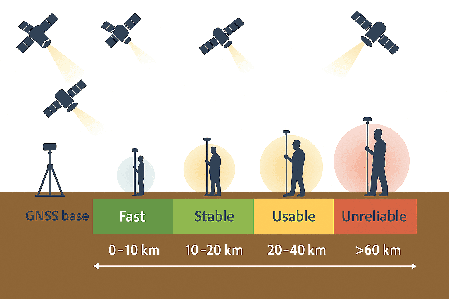
RTK remains the benchmark for centimeter-level performance. It improves location results by combining GNSS observations with correction data from a known reference station. In a standard setup, four components matter most: a GNSS receiver on the moving asset, usually called the rover; a reference station or base station at a precisely known point; a communication link that carries correction data; and processing software or firmware that applies those corrections in real time. The accuracy gain comes from comparing what the base station should see against what it actually sees, then passing that error model to the rover so the rover can remove much of the shared noise. In practice, that includes reducing satellite clock and orbit error effects, accounting for atmospheric distortion, and resolving carrier-phase ambiguities that code-only positioning cannot handle nearly as well.
That basic kinematics-based approach is proven, but the traditional form of RTK comes with several well-known limits.
- Coverage is constrained because corrections are most effective within a bounded distance from the base station, and performance drops as that separation grows.
- Distribution is usually handled over cellular networks, which becomes less efficient as the number of devices increases.
- Performance depends on a reliable communication link, because delayed or interrupted corrections can quickly degrade real-time accuracy.
- Signals can still be affected by interference, jamming, spoofing, multipath reflections, and environmental obstructions such as buildings, trees, and terrain.
- At large scale, cost and system complexity rise because networks need more reference stations, more data delivery capacity, and tighter operational monitoring.
Precise Point Positioning, especially PPP-RTK variants, can extend operational range and reduce dependence on nearby base infrastructure. The issue is that many current implementations are still proprietary and do not yet rest on a broadly shared standard. So while the underlying idea is promising, the market still lacks a universally adopted framework.
It also helps to separate RTK from PPK, since the two are often grouped together. RTK, or Real-Time Kinematic, applies corrections while the asset is operating, which makes it useful when a vehicle, drone, or robot needs immediate position updates. PPK, or Post-Processed Kinematic, records observations first and applies the corrections later, which is common in mapping, surveying, and other workflows where the best answer can arrive after the field session ends. RTK is about live decision-making. PPK is about deferred accuracy and cleanup. From what I’ve seen, the choice is less about one method being better overall and more about whether the job needs instant positioning or can tolerate post-processing.
If the industry expects to support billions of endpoints, many of them mobile and many of them mission-critical, then the correction layer has to meet a different set of requirements.
- It must work across broad geographic areas.
- It must stay efficient as device counts rise sharply.
- It must hold up better against interference and service disruption.
- It must remain cost-effective for high-volume deployments.
That is where a hybrid model becomes less of an experiment and more of a practical architecture choice. In another field, the word hybrid can mean a biological mix of two parent systems. The networking version is not so different: combine two delivery paths, let each do what it does best, and avoid forcing one network to carry every burden.
Hybrid RTK as a Dual-Path Correction System
Hybrid RTK means GNSS correction data is delivered through two coordinated channels.
- Primary path: ATSC 3.0 broadcast
- Fallback path: Cellular using LTE or 5G
- Upstream path: Cellular for acknowledgments, telemetry, and other device data
Compared with a satellite-only correction approach, or with a cellular-only RTK service, this design is more balanced. It uses a terrestrial television broadcast layer for the heavy downstream load and keeps cellular for the return path and gap coverage. That split is what gives the model its practical strength.
In operational terms, the workflow is fairly straightforward. A base station or correction network measures GNSS errors at known locations and packages those corrections for distribution. Devices equipped for hybrid RTK receive the shared downstream correction stream over broadcast whenever that path is available, while also maintaining a cellular path for telemetry, acknowledgments, session management, and continuity in areas where broadcast reception is weak or unavailable. The rover’s processing software then applies the incoming corrections to its own raw GNSS observations in real time. If you think of the correction feed as a shared reference layer, broadcast carries the common layer efficiently to many receivers at once, while cellular handles the individualized back-and-forth that broadcast cannot.
Why Broadcast Leads the Design
ATSC 3.0 offers one-to-many delivery efficiency, stable capacity, consistent latency characteristics, broad area coverage, and lower cost per delivered bit. It also performs well in dense urban settings where propagation and congestion can complicate other communication paths. For mass distribution of correction data, that matters a lot.
I looked through several deployment scenarios and the pattern was pretty clear. Broadcast handles shared downstream data the way a good map tile service handles common basemap requests: send it once, let many receivers use it, and avoid rebuilding the same stream device by device. Cellular was never optimized for that kind of repeated multicast demand at massive scale.
Why Cellular Still Matters
Cellular remains important because it covers the places where ATSC 3.0 is not yet fully available, supports uplink traffic such as status messages and position feedback, and handles mobile two-way use cases that broadcast alone cannot solve.
- It fills coverage gaps.
- It carries device telemetry and acknowledgments.
- It supports mobility scenarios that need two-way communication.
The result is a nationwide correction framework that is both resilient and scalable, with each network carrying the traffic type it is best suited to handle.
EdgeBeam Wireless and a Broadcast-First Buildout
EdgeBeam Wireless is building a hybrid RTK network around existing U.S. broadcaster infrastructure. That includes secure sites, hardened towers, and engineering assets already distributed across the country. The same footprint can be used not only to transmit over-the-air RTK corrections, but also to colocate GNSS base stations that complement current reference networks.
There are several practical benefits to that approach.
- Faster deployment of additional GNSS base stations
- Reduced infrastructure costs compared with cellular-only correction networks
- Improved reliability by using broadcast for downstream delivery
- Better scalability in dense IoT environments where many devices need the same data
- Expanded national reach as ATSC 3.0 coverage continues to grow
EdgeBeam markets this broadcast-first concept as Enhanced GPS, or eGPS, but the clearest way to understand it is as hybrid RTK with broadcast carrying the main downlink. Yes, it does require hardware capable of receiving the broadcast layer, but that hurdle looks manageable. The underlying chip ecosystem is tied to mass-market television adoption, which helps the economics. I checked several product references and the company already appears to have end-user options available for organizations that do not want to build custom integrations from scratch.
Broadcast RTK as an Edge Network Layer
Using ATSC 3.0 for correction delivery effectively creates a new network layer at the edge. It covers the last mile in a way that can serve GNSS and adjacent data applications at the same time.
- High-precision GNSS corrections
- Multicast distribution of positioning data
- Offloading of suitable high-volume traffic, such as video, from cellular networks
- Enterprise-grade reliability for industrial and transportation use cases
That division of labor is important. By moving the heavy downlink burden onto broadcast, cellular networks are free to focus on upstream messaging, mobility support, and the more interactive side of the workflow. In system design terms, it is a cleaner separation of functions.
This is not only about making one receiver more accurate. It creates the conditions for something much broader across fleets and infrastructure.
The main applications of RTK already make that clear. Surveying and mapping use it for high-accuracy field measurements. Agriculture uses it for guidance, repeatable passes, and machine control. Autonomous vehicles and ADAS use it to improve lane-level positioning. Robotics depends on it for navigation and localization in controlled spaces and changing outdoor environments. Infrastructure monitoring and industrial operations use it to track movement, alignment, and site conditions with more confidence than standard GNSS can usually provide.
A Shared Operating Picture With Centimeter-Level Reference
When large numbers of devices work from the same centimeter-grade spatial reference at the same time, you get what can be called shared situational truth, or shared situational awareness. In plain language, that means multiple systems can hold a common real-time understanding of location and timing across a fleet, corridor, site, or operating environment.
Hybrid RTK makes this possible by sending synchronized, high-precision PNT to many receivers at once. Then other communication networks, including cellular and internet-connected systems, can exchange each device’s position and related data locally or across broader platforms. It is a bit like aligning layers in GIS: once everything is in the same coordinate frame, the comparison becomes more useful and far less ambiguous.
What Is Shared
- Precise location
- Precise timing
Who Benefits
| Beneficiary | Description of Benefit |
|---|---|
| Vehicles | Gain more accurate positioning for navigation, lane-level awareness, and safer automated functions. |
| Fleet operators | Get a more consistent real-time view of asset location, timing, and route behavior across many units. |
| Drones | Improve navigation precision and collision avoidance in shared airspace and structured flight paths. |
| Industrial robots | Use centimeter-level localization to support repeatable motion, automation, and safer machine interaction. |
| Infrastructure sensors | Provide more dependable spatial and timing data for monitoring corridors, worksites, and fixed assets. |
| Emergency services | Benefit from faster coordination and clearer situational awareness during response operations. |
| Insurance and logistics systems | Work from cleaner location histories and synchronized event timing for analysis, claims, and operational planning. |
What It Enables
Once those systems are working from the same reliable reference, several higher-value applications become practical.
| Enabled Application | Description |
|---|---|
| Safer ADAS and ADS through lane-level awareness | Supports more dependable path positioning so automated driving systems can make better real-time decisions. |
| Collision avoidance for drones and autonomous machines | Improves relative positioning and timing between moving assets in shared operating areas. |
| Fleet optimization using tightly aligned movement history | Makes route analysis and operational comparisons more useful because the position record is more consistent. |
| Better insurance modeling based on dependable behavior measurement | Provides cleaner movement and event data for evaluating risk and reconstructing incidents. |
| Faster incident resolution using synchronized time and location records | Helps teams compare event sequences with less ambiguity across multiple devices and systems. |
| Infrastructure-to-vehicle coordination around hazards and work zones | Creates a more reliable shared reference for alerts, machine coordination, and traffic response. |
In transportation, that means the benefits extend beyond a single car or truck. A hybrid RTK layer can help make the entire traffic environment more predictable and safer, while doing it more efficiently than an approach built only on cellular delivery. During my analysis, that system-level gain stood out more than any single device metric.
RTK in Robotics and Automated Systems
RTK has an especially important role in robotics because robotic systems need precise navigation and localization, not just an approximate fix. Autonomous vehicles use RTK to improve lane-level positioning and to support safer path planning. Drones use it for tighter waypoint control, inspection work, and collision avoidance. Industrial robots and mobile machines use it to stay aligned with routes, work cells, or outdoor operating areas where repeatability matters. The practical benefit is that better positioning supports better automation: fewer location errors, more consistent machine behavior, and a stronger safety margin when robots are working near people, vehicles, or infrastructure.
Where RTK Technology Is Headed
The future of precise positioning will depend less on any single correction path and more on resilient hybrid delivery that can scale to millions of devices without losing accuracy.
The direction of travel is becoming easier to read. Broadcast integration is one of the clearest trends because it gives RTK and related correction services a more scalable distribution model. At the receiver level, multi-frequency and multi-constellation GNSS continue to improve robustness by giving devices more signals and more ways to cross-check them. Standardized correction formats should also matter more over time, because broad adoption is easier when devices and networks are not locked into narrow proprietary workflows. If those pieces continue to mature together, near-global coverage becomes more realistic, especially when regional broadcast, cellular fallback, and wider correction ecosystems are combined.
There is also a strong link to AI and IoT. As connected devices generate more data and automated systems make more decisions at the edge, positioning becomes another input that has to be clean, timely, and reliable. In my analysis, that is where hybrid RTK starts to look less like a niche upgrade and more like foundational infrastructure for large machine networks.
A Basic Shift in How PNT Gets Delivered
The combination of IoT expansion, stricter accuracy demands, and growing GNSS vulnerability is forcing a reset in positioning infrastructure. Hybrid RTK, with broadcast as the primary downlink and cellular as the supporting path, offers a practical answer. It is scalable, resilient, and better aligned with the economics of large deployments.
For sectors such as automotive, logistics, industrial automation, and public safety, high-precision PNT is moving from optional to necessary. As these hybrid networks mature, they will support new applications, more efficient operations, and higher expectations for how connected devices understand the world around them.
EdgeBeam Wireless is positioning itself to build that correction layer for the next generation of devices, the billions that will need precise, reliable location data in the years ahead.


