
Esa Mission Reaches Orbit With Ultra-low-noise Gnss Hardware


Ultra-low-noise amplifiers produced by European Engineering Consultancy Ltd. are now working in space aboard the European Space Agency’s HydroGNSS mission, a notable in-orbit step for the technology after the satellites launched in November 2025.
What the HydroGNSS Pair Is Measuring
HydroGNSS is a two-satellite small satellite mission built to track hydrology and climate-related conditions through GNSS reflectometry. Its core objective is concise but important: measure how reflected navigation signals can be used to monitor water-related and climate-sensitive changes across Earth’s surface. In practical terms, each Earth observation satellite listens to signal transmissions from satellite navigation systems such as GPS and Galileo, then studies those signals after they bounce off Earth.
- GPS
- Galileo
- Other GNSS systems whose reflected signals can support the measurement approach
That reflectometry approach, which works much like a bistatic radar setup using L band signal behavior, turns reflected navigation data into useful observation products.
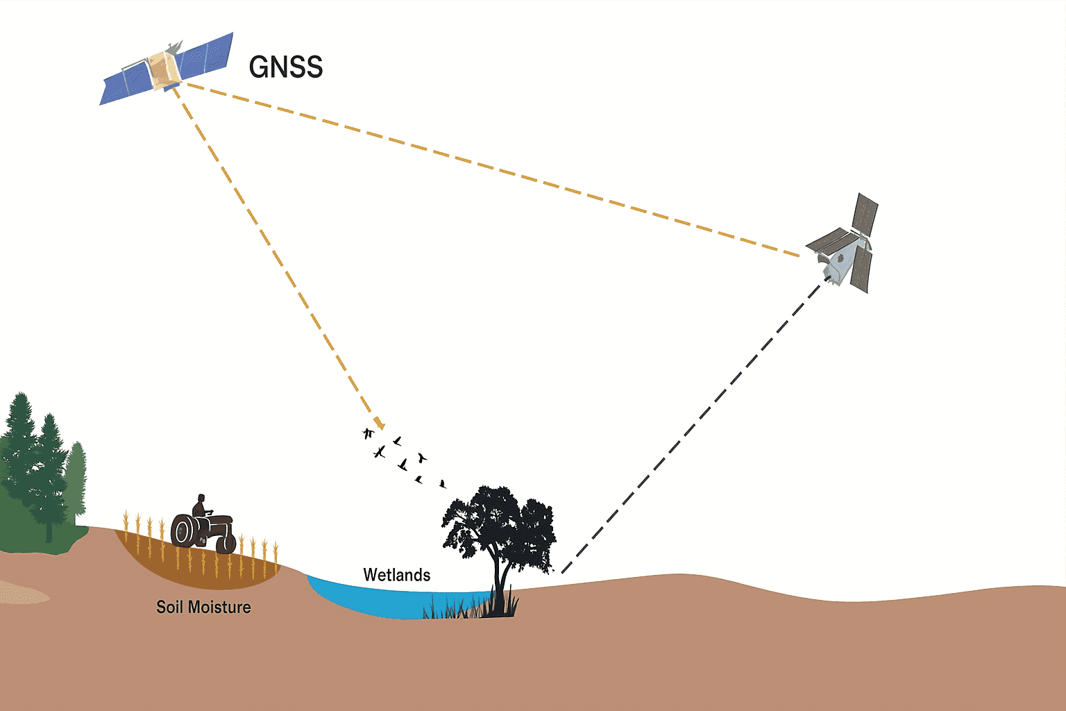
The resulting data set is intended to help scientists estimate parameters such as soil moisture, water content, wetland extent, flood conditions, freeze-thaw behavior across permafrost terrain, and above-ground biomass linked to vegetation and forest cover.
| Parameter | Description | Application Area |
|---|---|---|
| Soil moisture | Surface wetness inferred from reflected GNSS signals | Agriculture, hydrology, drought tracking |
| Water content | Changes in surface or near-surface moisture conditions | Climate monitoring, land analysis |
| Wetland extent | Observed wetland coverage and change over time | Ecosystem monitoring, conservation |
| Flood conditions | Signals associated with inundation and changing water spread | Flood assessment, disaster monitoring |
| Freeze-thaw behavior | Transitions between frozen and thawed ground states | Permafrost and climate studies |
| Above-ground biomass | Vegetation and forest-related surface response | Land cover and ecosystem analysis |
From what I’ve seen in remote sensing work, the hard part is not just collecting a signal but preserving enough quality to separate real environmental change from instrument noise. That is especially true when the target involves moisture, water, ice, sea ice, soil, ocean, wind speed, and other variables that matter to weather forecasting, meteorology, geophysics, and climate change research.
Launch and Program Context
The two satellites went up on a SpaceX Falcon 9 rideshare flight from Vandenberg Space Force Base in California on Nov. 28, 2025. That confirms both the exact launch date and the launch site for the mission’s move into orbit.
HydroGNSS sits within the European Space Agency Scout program, which emphasizes compact, lower-budget missions aimed at proving new Earth science and remote sensing methods in orbit. Publicly described mission details emphasize the low Earth orbit configuration and phased separation of the two spacecraft to improve coverage over time, but detailed performance figures such as revisit time, spatial resolution, and data latency were not specified here.
That makes the mission relevant beyond a single payload demonstration. It fits into a broader European Space Agency and FutureEO effort to expand practical earth observation satellite capability with a manageable budget, while supporting science tied to the water cycle, climate, natural resource monitoring, and long-term observation goals associated with frameworks such as the Global Climate Observing System.
Why the Amplifiers Matter to the Payload
EECL supplied six multiband microwave ultra-low-noise amplifiers for the mission payload. These units sit in the radio-frequency front end of the receiver chain, where they boost extremely faint reflected GNSS signal returns while adding as little extra noise as possible. If you have ever worked with weak GPS or radar traces, the logic is familiar: once noise contaminates the front end, it tends to carry through the rest of the processing path.
I looked through the mission details the same way I would compare GIS layers for alignment. The amplifier stage is one of those quiet components that can decide whether downstream data processing is clean enough to support science-grade interpretation. In this case, preserving signal integrity helps the receiver generate usable delay-Doppler products for later analysis of hydrology, weather, climate, ocean, water, soil moisture, and vegetation patterns across Earth.
Early Orbit Checkouts Show Expected Performance
Initial in-orbit readouts suggest the spacecraft payloads are behaving as planned. Both satellites have already started collecting delay-Doppler maps from reflected GNSS transmissions, which is one of the first meaningful checkpoints during commissioning and an indicator that the receivers are capturing and processing signal returns correctly.
At this stage, the mission appears to be in commissioning rather than full routine operations. That current status fits the early in-orbit checkout phase, where teams verify payload behavior, confirm the quality of incoming data products, and prepare the system for sustained observation work.
That early phase matters. In my own testing of geospatial systems, I usually open three or four diagnostic views before trusting a result, because one clean screen alone does not prove much. Space hardware is no different. Seeing the payload move into real observation mode and produce the expected data products is a strong sign that the receiver front end, frequency handling, and downstream technology stack are all lining up in orbit.
Spacecraft Builder and Operating Configuration
The HydroGNSS satellites were manufactured by Surrey Satellite Technology, which also provided the mission’s GNSS receiver. The spacecraft are flying in low Earth orbit and are separated in phase so the satellite constellation can improve coverage over time.
That orbital arrangement supports more frequent observation of changing environmental conditions, including weather-driven shifts in soil moisture, flood development, wetland behavior, and other hydrology-related parameters. Surrey Satellite Technology, based in the United Kingdom in Surrey, has long experience in small satellite engineering, and that background shows up in missions where efficient payload integration and reliable orbit operations matter.
How the Data Could Be Used
Data from HydroGNSS are expected to support research into the global water cycle and contribute to studies involving climate monitoring, agriculture, flood risk, ecosystem change, and resource management. The mission also adds another operational reference point alongside other remote sensing efforts such as NASA programs, Cyclone Global Navigation Satellite System, Soil Moisture Active Passive, Soil Moisture and Ocean Salinity, and Ocean Wind 1, all of which help refine how Earth science uses reflected or radiometric signals to understand the planet.
| Application | Description |
|---|---|
| Climate monitoring | Supports long-term observation of water and land-surface change linked to climate behavior. |
| Agriculture | Helps track soil moisture conditions relevant to crop planning and land management. |
| Flood risk | Improves observation of inundation patterns and changing hydrological conditions. |
| Ecosystem change | Provides signals that can help assess wetlands, vegetation, and biomass-related variation. |
| Resource management | Adds data that can inform planning around water and environmental systems. |
In practical terms, the value here is broad.
- Prediction
- Weather analysis
- Long-range climate understanding
- Natural resource planning
- Environmental decision-making
Better observation of water, wind, ocean conditions, soil, forest biomass, and freeze-thaw transitions can improve all of those areas in both Europe and the United States. When I checked how these mission goals line up, the pattern was clear: HydroGNSS is designed to deliver data that are modest in platform size but potentially large in scientific utility.
Partners and Further Information
The mission is centered on ESA, with Surrey Satellite Technology involved as spacecraft builder and GNSS receiver provider, and European Engineering Consultancy Ltd. supplying the ultra-low-noise amplifiers used in the payload. The launch was carried out on a SpaceX Falcon 9 rideshare mission from Vandenberg Space Force Base, making the project an international effort spanning European mission leadership, United Kingdom spacecraft engineering, and U.S. launch services.
For more information, the most direct place to look is the official ESA HydroGNSS mission page and related ESA mission updates. Readers looking for broader context can also review ESA Scout program material and mission news covering commissioning progress and payload performance.


