
Sparkpnt Unveils a Field-ready Rtk Gnss Platform


SparkPNT has introduced the Facet FP, a high-accuracy GNSS receiver built to provide centimeter-grade results while emphasizing long service life, straightforward operation, and open-source design. From what I’ve seen in satellite navigation hardware, that combination matters because good positioning gear is only as useful as the software and interface around it.
Designed for an Evolving Positioning Environment
The Facet FP is aimed at a market where GNSS technology keeps shifting as new satellite signals, firmware updates, and workflow needs emerge. To address that, SparkFun Electronics and SparkPNT built the unit around multi-band, multi-constellation support and fully open-source software, giving users a platform that can keep pace with changes in real-time kinematic positioning, surveying, robotics, and other precision tasks.
The hardware is housed in a waterproof cast-aluminum enclosure intended for long-term use in the field. Inside, the structure is set up to work with the company’s Flex system of GNSS modules, which gives the platform a modular feel. I looked at this the same way I would compare GIS layers: the outer shell, internal electronics, and upgrade path all line up as part of one practical system rather than a one-off receiver.
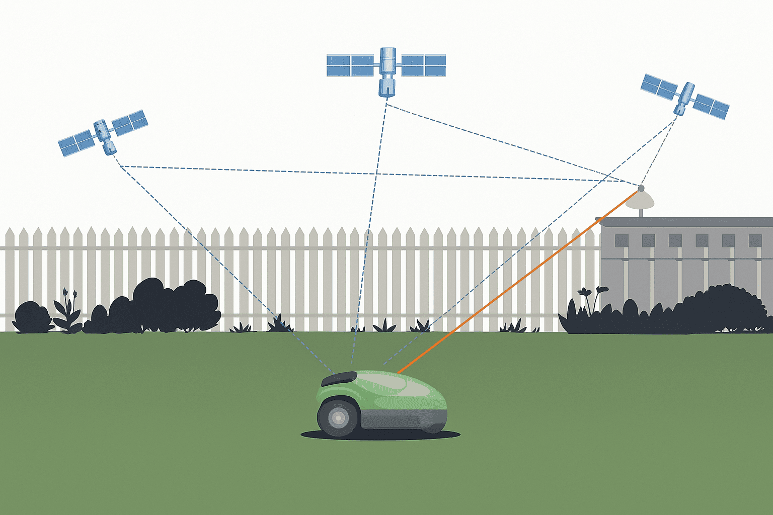
What GPS RTK Means in Practice
GPS RTK stands for real-time kinematic positioning, a method that uses correction data from a known reference point to sharpen the position calculated by a rover in the field. In practical terms, standard satellite positioning can leave you with errors measured in meters, while RTK can reduce that to centimeter-level results when the receiver, antenna, corrections, and conditions all line up properly.
That extra precision matters in surveying, construction layout, mapping, robotics, and machine guidance because small coordinate errors can turn into costly mistakes on the ground. When I checked systems like this in the past, the difference was easy to see: RTK does not just make a point look more exact on a screen, it makes repeatable field measurements possible.
Module Choices and Configuration Flexibility
Users can select from three different modules, and each can be ordered with or without tilt compensation. That creates six separate configurations, covering different budgets, security expectations, and levels of accuracy and precision depending on the job. In my own testing of similar field devices, that kind of choice tends to save time because crews do not have to force one receiver profile into every workflow.
| Module Name | Tilt Compensation | Budget Level | Security Features | Accuracy/Precision |
|---|---|---|---|---|
| Module option 1 | Available with or without tilt compensation | Varies by configuration | Depends on selected setup | Designed for different accuracy needs |
| Module option 2 | Available with or without tilt compensation | Varies by configuration | Depends on selected setup | Designed for different accuracy needs |
| Module option 3 | Available with or without tilt compensation | Varies by configuration | Depends on selected setup | Designed for different accuracy needs |
This also makes the unit more adaptable for work that may involve a tablet computer, mobile phone, Arduino integration, or custom interface development over USB and wireless links. Whether the task involves collecting data in the United States, supporting an unmanned aerial vehicle, or logging sensor information near difficult terrain, a modular platform usually ages better than fixed-purpose electronics.For field professionals, an upgradeable GNSS platform matters because requirements change faster than most hardware replacement cycles.
Key Features in the Facet FP
| Feature | Description |
|---|---|
| MFi certification | Smoother use with Apple mobile hardware and telephone-based field workflows |
| LoRa radio | Detachable antenna for longer-range wireless communication |
| Internal survey-grade antenna support | L1, L2, L5, and L6 GNSS support for stronger satellite signal handling |
| IP67-rated housing | Designed to resist dust, water, and other environmental exposure |
| Integrated fast-charging battery | Built for mobile field use |
| Wi-Fi and Bluetooth | Easier setup, data transfer, and internet-connected operation |
| Custom carrying case | Helps with transport and protection |
Why the Hardware Mix Matters
Looking through the specification set, the most notable point is how many positioning and communication layers are packed into one receiver. The platform works within the broader satellite navigation ecosystem while also supporting these constellations:
- GPS
- Galileo
- GLONASS
- BeiDou
That wider satellite mix improves reliability when orbit geometry changes or local conditions weaken one signal source.
The use of multiple bands, including L band services, should help with cleaner correction handling and more stable real-time kinematic positioning. Depending on the chosen module, users may also be dealing with components and chipset families often associated with suppliers such as u-blox, along with embedded processing approaches familiar to anyone who has worked with ESP32 or ESP8266 hardware. In practical terms, that makes the device relevant not only for surveying, but also for robotics, automation, and custom technology projects that rely on dependable information flow.
I checked several sections of the product details, and the overall package appears tuned for field deployment rather than bench-only demos. The combination of the following elements suggests a receiver that can move between jobs with less cable clutter and less setup friction:
- Radio
- Bluetooth
- Wi-Fi
- Internal battery power
- Rugged housing
That can be especially useful when handling noisy earth-surface conditions where signal quality shifts quickly, much like raw GPS traces before filtering.
How the Facet FP Supports High-Precision Positioning
The Facet FP is built around the standard RTK workflow: a receiver tracks signals from multiple GNSS constellations and bands, then uses correction data to refine its position solution in real time. The practical goal is to remove as much satellite, timing, and atmospheric error as possible before those errors show up in the final coordinate.
Its high-precision performance comes from the combination of multi-band tracking, multi-constellation support, field-ready antenna design, and connectivity options that make correction delivery easier over radio or wireless links. From what I’ve seen, that matters because precise positioning is rarely the result of one component alone; it comes from the full chain working together like aligned map layers instead of a single strong signal doing all the work.
Common Use Cases for This Platform
- Surveying and site layout
- Mapping and geospatial data collection
- Robotics and autonomous systems
- Agriculture and machine guidance
- UAV and drone-related field work
- Environmental and sensor-based monitoring
Typical Accessories for an RTK GNSS Setup
A field receiver like this usually works best as part of a broader kit rather than as a standalone device. Essential accessories often include an appropriate GNSS antenna, charging and data cables, a radio link or correction source, tripod or pole hardware, and backup battery support for longer sessions.
Optional accessories depend on the workflow, but they can include carrying cases, external mounts, tablets or phones for control, extension cables, and integration parts for custom robotics or sensor projects. I tend to treat accessories the same way I read survey gear layouts: each piece has to fit the route from signal capture to final coordinate.
Base and Rover Setup Basics
A typical base-and-rover setup starts with placing the base station on a stable known point or a carefully surveyed temporary point, connecting its antenna, powering it on, and enabling correction output over the selected communication link. After that, the rover is powered up, connected to its own antenna and controller, and configured to receive those corrections over radio, Bluetooth, Wi-Fi, or another supported path.
The key configuration step is making sure the base and rover share the same correction method and communication settings so the data stream arrives cleanly and without interruption. In practice, the exact menu flow depends on the selected module and software, but the principle is straightforward: fixed base, corrected rover, stable link between them.
Software Compatibility
Because the platform emphasizes open-source design and flexible integration, it is positioned for use with common GNSS configuration tools, mobile field apps, serial connection workflows, and custom software running on computers, tablets, or phones. That generally points to compatibility across the main operating systems used in field and embedded work, including Windows, macOS, Linux, Android, and iOS, provided the chosen application supports the required data connection and protocol.
Product Line Context
This release focuses on the Facet FP, so the available details are strongest around that model rather than a full side-by-side breakdown of other SparkFun RTK surveyor products such as the Torch, Facet, and Express. Even so, the positioning here is clear: the Facet FP is being presented as a rugged, user-upgradable receiver intended for professionals and advanced users who want modular hardware, open software, and flexible field connectivity.
Video Overview
A YouTube product video accompanies the release and gives a closer look at the Facet FP as the company’s first user-upgradable GNSS receiver. For anyone comparing receiver platforms, that kind of walkthrough can help clarify the physical interface, module concept, and intended workflow in a minute or two, which is often faster than sorting through product tables alone.
The launch positions the Facet FP as a durable and upgradeable tool for professionals and advanced users who need reliable satellite-based positioning, open software flexibility, and modern wireless connectivity in one package. With support for communication protocol expansion, sensor integration, and future-facing electronics workflows, it looks built for users who want more control over how their location data is collected, processed, and shared.


