
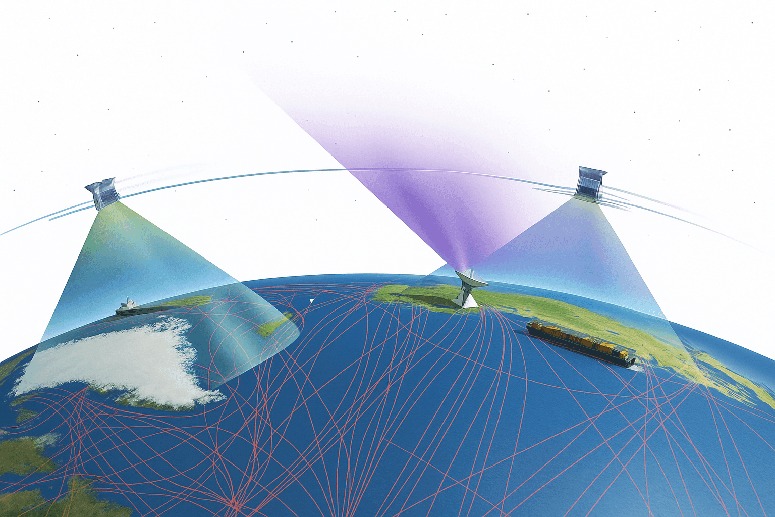
Arkedge Space Expands Maritime Tracking With a Three-satellite Network


ArkEdge Space reported that its micro-satellite AE1a was launched successfully on March 30 and has now moved into early checkout after communication was confirmed through test radio signals. From what I’ve seen in space systems coverage, that first verified signal matters a lot; it is the point where a spacecraft moves from launch success to usable in-orbit validation.
AE1a’s Role in the Demonstration Program
AE1a is a technology demonstration satellite built to support maritime digitalization through broad-area, real-time ship tracking and communication. The satellite uses ArkEdge Space’s standardized 6U satellite bus with a large antenna configuration, a practical design choice for handling very high frequency work over the sea. In simple terms, the platform is meant to improve navigation-related awareness, vessel information flow, and data handling across wide maritime zones.
The mission is also intended to prove a deployable antenna for VDES use while refining and validating key technologies tied to a VDES receiver. When I checked the structure of the program, it looked a bit like comparing GIS layers: one layer handles the hardware proof point, another handles signal reception, and a third confirms whether the overall communication system will scale into reliable operations in low Earth orbit.
Beyond the antenna work, the design points to a broader micro-satellite approach built around modularity and repeat use. The 6U bus suggests a platform ArkEdge can adapt for different payloads, while the standardized structure should make integration, power management, and onboard data handling easier across multiple missions. From what I can map out from the program as described here, the emphasis is less on a one-off spacecraft and more on a flexible small-satellite system that can be configured for communications, technology validation, and other compact payload roles.
How the Constellation Is Being Built
AE1a will work alongside AE1d, which entered service in January 2025, and AE3Va, which began operating in June 2025. Together, the three spacecraft form a small satellite constellation intended for demonstrations across broad maritime regions. That matters because a lone satellite can provide useful observation windows, but a constellation improves timing, revisit coverage, and overall situation awareness in outer space applications tied to Earth and the sea.
| Satellite Name | Launch/Service Date | Mission Purpose | Status |
|---|---|---|---|
| AE1a | Launched March 30 | Technology demonstration focused on VDES reception, deployable antenna validation, and maritime tracking support | Early checkout after initial communication confirmation |
| AE1d | Entered service in January 2025 | Part of ArkEdge Space’s maritime demonstration constellation | In service |
| AE3Va | Began operating in June 2025 | AIS signal collection across maritime regions and sea lane monitoring | Operating |
In practical terms, this is the step from a single satellite test toward a more usable communications satellite framework. It also reflects how private spaceflight programs often mature: first prove the payload and bus, then validate orbit performance, then expand toward repeatable service and, eventually, mass production if the data supports it.
The constellation angle also says something about ArkEdge Space’s likely service model. Rather than only building an individual spacecraft, the company appears to be working across the full chain of constellation design, deployment, in-orbit operations, and data collection tied to maritime users. That is important because the value in these systems usually comes from the network as a whole, not just from one satellite passing overhead.
Based on the projects named here, ArkEdge Space’s disclosed micro-satellite work in this article includes AE1a, AE1d, and AE3Va, with AE1a positioned as the newest demonstration spacecraft and the other two already supporting operational testing. The article does not identify additional past or planned satellites beyond these missions, so this is the clearest confirmed project list available in the current coverage.
Signal Collection Across Busy Sea Lanes
AE3Va is already collecting AIS signals from several maritime areas, including waters near Japan and heavily traveled sea lane corridors. Those routes are exactly where tracking quality, radio performance, and automatic identification system reception become most valuable. Over the course of reviewing similar programs, I’ve found that busy shipping zones often reveal the real strengths and weaknesses of a payload much faster than quiet waters do, because the signal environment is denser and the data is less forgiving.
ArkEdge says the accumulated reception data is now being verified and analyzed in a systematic way. That kind of review is essential. It is not enough to show that a satellite can hear a signal; the real test is whether the information lines up consistently across time, geography, and operating conditions, much the way noisy GPS traces need filtering before they become trustworthy.
What Comes After Reception Testing
The next phase will move beyond reception-focused work and toward two-way communication, including transmissions sent from orbit. If that stage performs as planned, the system should allow satellites to send operational information directly to ships, broadening the VDES demonstration from passive monitoring into active communication.
That progression is significant for the maritime sector because it shifts the project from basic observation toward concrete service validation. A stronger communication layer in space can support ship operations, improve sea-based information exchange, and create a clearer path toward practical use cases.
- Hosted payload design
- Ground station integration
- Spacecraft attitude determination and control
- Optical communication planning
- Broader space exploration capabilities
In the longer view, that same flexible satellite approach could support several mission types, including communications, technology demonstration, hosted payload missions, scientific research, and selected Earth-focused observation tasks where small spacecraft are a good fit. While this article centers on maritime communications, the underlying system appears broad enough to support more than one mission profile if the payload, orbit, and power budget line up.
While this mission is not about the moon, deep space exploration, or an earth observation satellite in the traditional sense, it still shows how modern satellite technology is expanding what small spacecraft can do around Earth. The combination of antenna design, payload validation, radio performance, and orbital communications is where much of today’s real progress in space and satellite navigation infrastructure is happening, especially from companies working out of places like Tokyo and the broader Japanese commercial space sector.
Company Background and NewSpace Context
This article focuses on the AE1a mission and the related maritime constellation, but it does not provide a documented corporate history for ArkEdge Space, a headquarters address, or a list of key employees. It also does not name founders, executives, or other team members, so those details cannot be confirmed from the material here without adding unsupported information.
What can be said from the project itself is that ArkEdge Space fits the general NewSpace pattern. NewSpace usually refers to commercially driven space activity built around faster development cycles, smaller satellites, lower-cost deployment models, and services designed for practical customers rather than only large government programs. In that sense, ArkEdge’s use of compact satellites, demonstration-led development, and constellation-based maritime services lines up well with the NewSpace model.


