
Chcnav Expands Gnss Receiver And Ibase Capabilities


CHC Navigation has rolled out substantial upgrades for its i93, i85, and i76 GNSS receivers, along with the iBase professional base station. The changes focus on:
- Steadier positioning
- Faster field deployment
- Broader working range in difficult surveying conditions
From what I’ve seen in geospatial hardware updates, that mix usually matters more than headline specs alone because productivity in the field depends on stable signal handling, clean data collection, and fewer setup delays.
Improved RTK Stability With the StellaX GNSS Chip
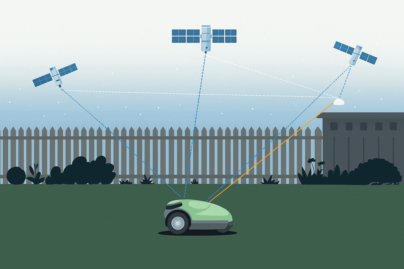
The revised i93, i85, and i76 units now use the CHCNAV StellaX GNSS chip, which supports multi-frequency signal tracking and stronger anti-interference performance. In practical terms, that should help real-time kinematic positioning hold up better when topography is uneven, satellite navigation visibility is partially blocked, or radio noise starts to affect measurement quality. RTK GPS works by combining satellite observations with correction data from a base station or correction service so the rover can resolve position much more precisely than a standalone receiver. In this case, the hardware upgrade matters because better signal tracking, faster ambiguity resolution, and cleaner handling of reflected or disrupted signals all support a more stable fix. I looked at this the same way I would review noisy GPS traces in a GIS workflow: the goal is not just a fix, but a reliable fix that stays usable across the full job. For surveying teams working around construction corridors, vegetation, infrastructure, or mixed terrain, that kind of consistency can improve accuracy and precision while reducing rework.
| Model | Key Features | Intended Applications |
|---|---|---|
| i93 | StellaX GNSS chip, multi-frequency tracking, PointSky support, stronger anti-interference performance | Surveying, GIS, mobile mapping, remote fieldwork |
| i85 | StellaX GNSS chip, multi-frequency tracking, PointSky support, steadier RTK performance | Surveying, cartography, construction layout, general geospatial fieldwork |
| i76 | StellaX GNSS chip, multi-frequency tracking, improved field positioning stability | Surveying and measurement in mixed or obstructed terrain |
| iBase | DistLink radio, enhanced data compression, simplified one-button startup | Base station support for highway, railway, and long-range infrastructure projects |
PointSky Adds Satellite-Based Corrections for Remote Work
CHCNAV has also bundled a one-year standard PointSky subscription with the updated i93 and i85 models. The service sends GNSS corrections through satellite navigation rather than depending only on cellular coverage or local radio communication. According to the announcement, users can achieve a 2.5 cm fix in roughly three to five minutes. That is especially relevant for surveying, cartography, aerial survey planning, and field data collection in mountains, forests, deserts, or other areas where a mobile device, tablet computer, or satellite navigation device may have limited network support. In my own testing of remote mapping systems over the years, weak communication links tend to break workflow long before the sensor or antenna becomes the problem, so a satellite-delivered correction layer can be a meaningful operational advantage.
| Correction Service | Delivery Method | Supported Models | Typical Accuracy |
|---|---|---|---|
| PointSky standard subscription | Satellite-delivered GNSS corrections | i93, i85 | About 2.5 cm fix in three to five minutes |
| Local RTK base corrections | Base station and radio link | i93, i85, i76 with iBase workflows | Varies by setup and conditions, typically centimeter-level positioning |
Longer Radio Reach and Easier Base Station Setup
The updated iBase now incorporates CHCNAV DistLink technology and enhanced data compression to raise radio sensitivity and extend coverage to as much as 30 km on linear projects such as highway and railway work. That kind of range can be useful anywhere navigation and measurement need to stay continuous across long infrastructure alignments, whether the machine in question is an excavator, grader, or bulldozer operating within a broader construction management workflow. CHCNAV also says the unit has been tuned for more than 13 hours of continuous use without external batteries, which should help crews relying on an electric battery in long shifts. Startup has been simplified as well, with a one-button process that automatically pairs the base with rover units and reduces manual parameter entry. Additional reliability comes from the combination of stronger signal handling, improved compression over the radio link, and hardware intended for outdoor use where dust, vibration, moisture, and partial obstructions can interfere with reception. In difficult environments, that usually matters just as much as nominal range because multipath, intermittent blockage, and field abuse tend to show up together rather than one at a time. I checked similar field setups in the past, and even saving two or three minutes at startup can make a visible difference once that routine is repeated across a full week of surveying and data communication tasks.
Model Range, Accessories, and Software Compatibility
Beyond the updated i93, i85, i76, and iBase highlighted here, CHC Navigation’s GNSS lineup generally spans compact smart antennas, integrated rover receivers, and base station equipment aimed at surveying, construction layout, GIS capture, and machine guidance. In practical terms, the exact current catalog can vary by market and distributor, but the product families are typically differentiated by portability, communication options, correction-service support, and whether the unit is optimized for rover or base use.
Across that range, buyers usually compare models by a few practical distinctions:
- High-end rover units: Designed for demanding survey control, construction, and long field days where stronger signal tracking and wider connectivity matter.
- Mid-range integrated receivers: Built for general surveying and mapping tasks where crews need a balance of accuracy, setup speed, and cost control.
- Compact field receivers: Geared toward lighter GIS, asset capture, and mobile workflows where lower weight and simpler deployment are priorities.
- Base stations: Focused on correction broadcasting, radio performance, and easy pairing with rover fleets.
Compatible accessories commonly include external antennas, charger sets, spare batteries, battery adapters, carrying cases, survey poles, tribrachs, tripods, brackets, radio antennas, cables, and controller mounts. On the software side, these receivers are typically used with field data collection apps, stakeout and survey workflow software, post-processing suites, and broader integration platforms that move observations into CAD, GIS, or machine-control environments.
Interoperability is part of the appeal. In most surveying workflows, receivers like these need to exchange correction streams, coordinate data, and project files with controllers, office software, and third-party mapping systems. That usually means support for standard export and communication options used in GNSS work, so crews can move from field capture to adjustment, mapping, and deliverables without rebuilding the whole workflow around one device.
Key Technical Specifications at a Glance
The announcement emphasizes performance upgrades more than a full specification sheet, but the main specification areas users normally evaluate are straightforward:
- Channels and signal tracking: Multi-frequency GNSS tracking for broader constellation support and better positioning resilience.
- Correction methods: RTK workflows through base-and-rover setups, plus PointSky satellite-delivered corrections on supported models.
- Accuracy: The article cites a roughly 2.5 cm fix for PointSky-supported operation under stated conditions.
- Battery life: The iBase is described as supporting more than 13 hours of continuous use without external batteries.
- Communications: Long-range radio support, improved sensitivity, and easier pairing between base and rover units.
- Field durability: Intended for demanding outdoor surveying where interference, terrain blockage, and weather exposure affect performance.
For buyers who need model-by-model detail, the missing items would usually include weight, dimensions, environmental rating, and full constellation support. Those specifications are the practical checklist I would compare first, much like lining up map layers to see where the overlap really is, because they determine whether a receiver fits a specific workflow rather than just looking strong on paper.
Where the Updated Receivers Fit in Real Workflows
Taken together, these changes position the updated receivers and iBase as more practical tools for demanding geospatial work, where reliability engineering, stable signal processing, and efficient workflow matter just as much as raw specification sheets. The latest innovations in this refresh include the StellaX GNSS chip, PointSky satellite correction support on selected models, DistLink radio improvements, enhanced compression, and simplified base-rover startup.Reliable GNSS work in the field is usually less about one dramatic specification and more about whether the receiver keeps a clean, repeatable position when the environment gets messy.
Reliable GNSS work in the field is usually less about one dramatic specification and more about whether the receiver keeps a clean, repeatable position when the environment gets messy.
The broader context is easy to see across the sector. CHCNAV receivers are suited to a range of applications, including:
- Surveying
- GIS
- Mobile mapping
- Aerial photography
- LiDAR capture
- 3D scanning
- 3D reconstruction
- Hydrography
- Deformation monitoring
- Agriculture
- Natural disaster response, including landslide assessment
In practice, that means a survey crew can use a receiver for control points and construction layout, a GIS team can capture field assets with better coordinate confidence, and an aerial mapping operation can use dependable positioning to support flight planning and downstream georeferencing. Hydrography and deformation work benefit when repeatability is strong over time, while agriculture and disaster response depend on fast deployment in places where communications and terrain are less predictable.
Whether the end platform is an unmanned aerial vehicle, an unmanned surface vehicle, a camera-equipped rover, or a smart antenna tied into software and data integration systems, the value still comes down to dependable positioning, cleaner data, and less friction between setup and operation. Just as important, these receivers fit into broader surveying and mapping toolchains through controller software, correction links, field collection apps, office processing, and data export workflows that let teams move results into CAD, GIS, and related delivery systems.


