
Bangladesh Moves to Settle Its Tallest Peak Question


A government-backed measurement campaign is now underway to identify the highest mountain in Bangladesh. Teams from the Survey department under the Ministry of Defense have started field operations in the remote hill country of Ruma and Thanchi upazilas in Bandarban District, part of the Chittagong Hill Tracts near Myanmar and India.
Fieldwork Begins in Bandarban District
The operation is scheduled for April 4-12 and relies on modern geodetic practice, advanced GNSS tools, and Global Positioning System-based positioning. From what I’ve seen in similar survey setups, the hard part is rarely the instrument menu; it is getting clean observations in rugged hill terrain where access, canopy, and line of sight can distort the signal. Here, crews are working to establish the latitude, longitude, and elevation of the leading summit candidates with centimeter-level accuracy above mean sea level.
- Ruma Upazila
- Thanchi Upazila
- Bandarban District
- Chittagong Hill Tracts
- Close to the borders with Myanmar and India
The result should give Bangladesh a more defensible answer on the height of its top mountain, with measurements tied to international standards rather than old estimates or repeated local claims in the Bengali language and other regional usage.Accurate summit measurement matters because a national high point should rest on survey-grade evidence, not on repeated claims.
How GNSS Data Will Be Converted to Sea Level Height
According to the government, the survey will use a newly developed geoid model to turn ellipsoid heights collected by GNSS receivers into elevations referenced to sea level. I tend to think of this the way I compare GIS layers: one layer shows raw positional data, while another helps translate that information into something meaningful on the ground. Without that conversion step, even precise satellite observations do not fully answer the sea-level question.
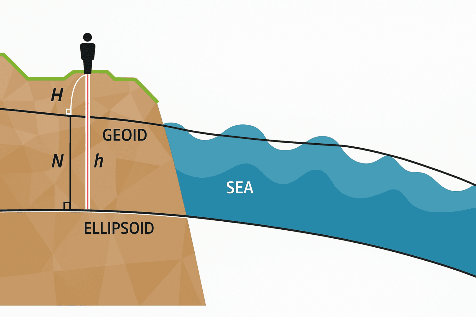
That matters because elevation and height are not always interchangeable in technical work. In practical surveying, the summit reading from a receiver has to be adjusted through the geoid so the final figure reflects mean sea level rather than a purely mathematical surface. In remote mountain zones, that distinction is what separates a decent estimate from a defensible national benchmark.
Peaks at the Center of the Debate
The survey is expected to address a long-running dispute over whether Tajingdong, Keokradong, or Saka Haphong is the true highest summit in Bangladesh. Until the government releases a final official result from the current campaign, Saka Haphong is widely treated as the leading candidate in many modern trekking and survey discussions, while older claims often favored Keokradong or Tajingdong. Official recognition, though, remains the key point the new measurements are meant to settle.
| Peak Name | Elevation (m) | Location | Notable Features |
|---|---|---|---|
| Saka Haphong | Often cited at about 1,052 | Bandarban District, near the Myanmar border | Frequently identified as the leading candidate for Bangladesh’s highest peak; important in trekking and local geographic discussion |
| Keokradong | Often cited at about 986 | Bandarban District | One of the country’s best-known trekking peaks and long associated with claims of being the highest |
| Tajingdong | Often cited near 1,280 in older claims, though that figure is disputed | Bandarban District | Central to the long-running height debate; published figures have varied widely |
Saka Haphong, also called Saka in some references and linked by some local naming traditions to Zow Tlang in the Bawm language, has often been discussed alongside Keokradong in this debate. It is notable not just because of the height claim, but because it sits in a remote borderland landscape that has drawn trekkers, local geographic interest, and repeated debate over naming, mapping, and measurement. That combination of cultural reference, difficult access, and disputed elevation is a big part of why the peak remains so prominent in discussions about Bangladesh’s highest mountain.
When I checked how these claims are usually presented, the pattern looked a lot like noisy GPS traces before cleanup: several points seem plausible, but only a careful survey can show which one actually stands highest. With Bandarban District bordering the larger upland system that connects toward Chittagong, Rangamati District, Myanmar, and India, even small differences in measured elevation can keep the argument alive for years. This field campaign is meant to close that gap with survey-grade data rather than assumption.
How the Main Peaks Compare
Based on commonly cited figures rather than a newly published official ranking, the current practical order is often presented this way: Saka Haphong as the leading candidate for the highest peak, Keokradong as a lower but more widely visited summit, and Tajingdong as a peak surrounded by older and disputed elevation claims. That also means the answer to the second-highest question is not fully settled in an official sense. If Saka Haphong is confirmed as the highest, Keokradong is often treated as the second highest in popular summaries, with an elevation usually given at about 986 meters.
Tajingdong Peak lies in Bandarban’s hill region and is notable mainly because of the uncertainty around its reported elevation. It has appeared in older lists as a top contender for the country’s highest point, but the claim has been questioned for years. Keokradong, by contrast, is famous less for record status now than for visibility in Bangladesh’s trekking culture. Saka Haphong stands out because it combines remoteness, disputed measurement history, and strong symbolic value in the national search for a definitive highest summit.
Trekking, Ecology, and Border Complexity
Keokradong is generally regarded as a moderate-to-challenging trek, depending on route, season, and trail condition. Typical trips are done over one to two days from access points in Bandarban’s hill areas, and the main difficulties come from steep footpaths, heat, mud, rain, and limited services in remote terrain. Distances and elevation gain vary by route, so trail statistics are not fully standardized in the way they would be on a mapped park trail, and this article does not include an official photo archive or route gallery.
More broadly, mountain tourism in southeastern Bangladesh supports local guiding, transport, lodging, and food services, especially around established trekking corridors. These hill areas also matter ecologically because they hold forest habitat, watershed functions, and biodiversity that can be damaged by unmanaged foot traffic, waste, and slope disturbance. In my analysis, the challenge looks a bit like balancing map layers that do not always align: tourism brings local income, but fragile upland environments need careful protection.
As for border disputes, the article’s core issue is better described as boundary proximity and topographic ambiguity rather than a confirmed international territorial dispute centered on one famous summit. Many of these peaks sit close to the Myanmar frontier, and naming traditions, limited access, and inconsistent historical measurements have all contributed to confusion. That is one reason a precise official survey matters so much here.


