
Mikroe Adds an Xsens Mti-8 Click Board For Rtk Gnss And Ins Work


Mikroe has introduced the XSens MTi-8 Click, a compact add-on board built for high-accuracy positioning and orientation tracking in outdoor embedded system designs. The hardware is based on the Xsens MTI-8-5A, an RTK-enabled GNSS and inertial navigation system module that brings together satellite navigation, inertial sensing, and real-time sensor fusion in one small package. From what I’ve seen, this kind of integration is especially useful when a project needs reliable navigation data without the usual pileup of separate sensor and software components.
Like other Click boards, this module is meant to speed up proof of concept work, early evaluation, and the transition into prototype code for an embedded system. I looked through the feature set the way I would compare GIS layers on a field map: the value is not just in one data point, but in how positioning, motion, and orientation data line up across the whole stack.
Key Features
| Feature | Description |
|---|---|
| Centimeter-grade location output | It supports real-time kinematic positioning, with stated accuracy and precision down to 1 ppm CEP, a circular error probable figure that matters in surveying, robotics, and other navigation system use cases where small offsets add up quickly. |
| Fast sensor fusion processing | The module runs the Xsens algorithm at output rates up to 100 hertz, giving developers rapid dead reckoning and orientation updates during quick motion, which is important in real-time computing environments. |
| Integrated inertial sensing | The onboard sensor set includes a gyroscope, accelerometer, and magnetometer. Together they support roll and pitch estimation at 0.5° RMS and yaw at 1° RMS with GNSS assistance, helping motion capture, kinematics, and motion detector tasks stay stable even when satellite navigation gets messy. |
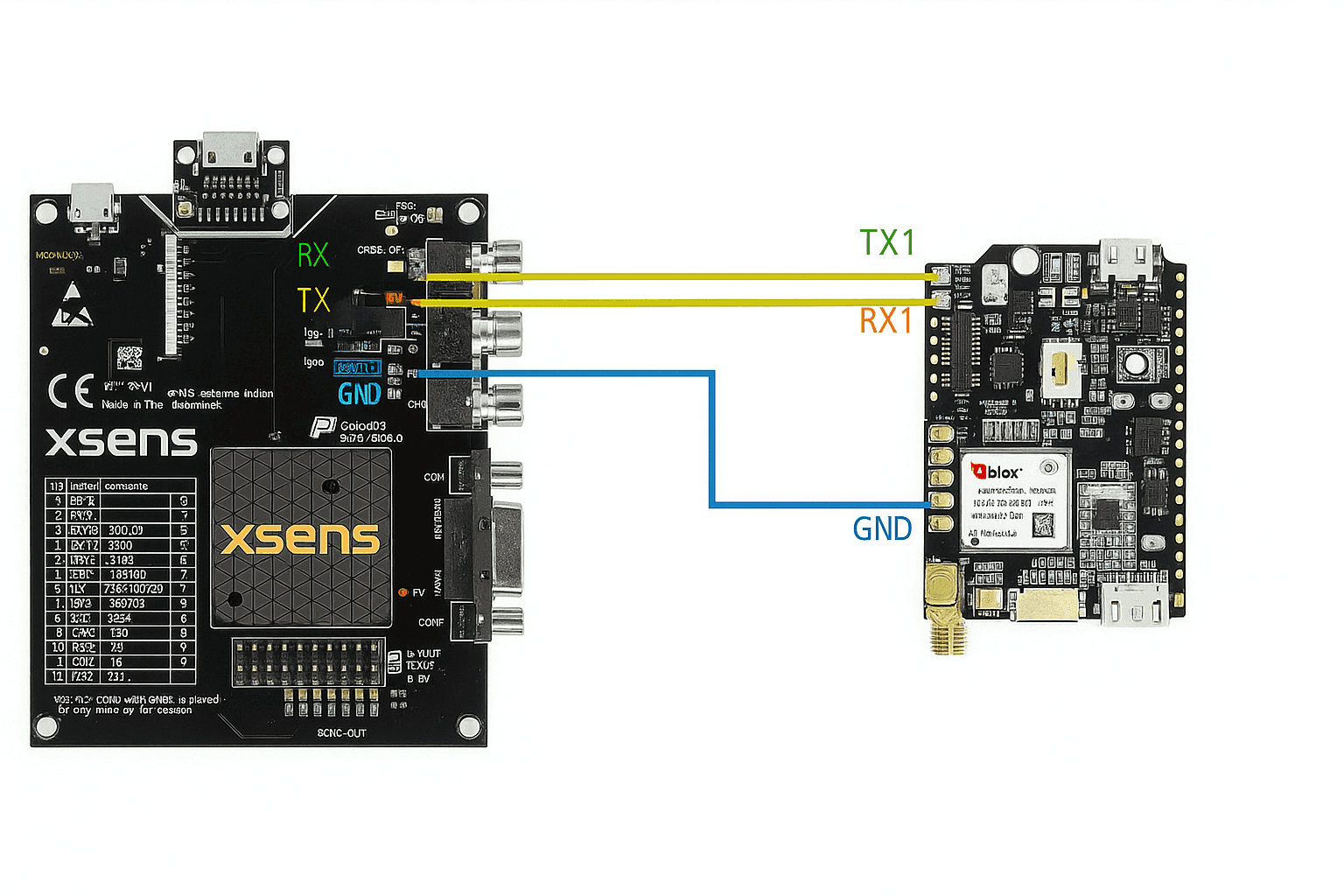
| Flexible connectivity | System integration is handled through UART, SPI, and I2C, along with a USB-C connection for setup, debugging, calibration, and bench testing. In practical terms, that means support for universal asynchronous receiver-transmitter links, serial peripheral interface buses, and standard interface computing workflows that fit a wide range of microcontroller platforms. |
| GNSS support | The board is built around a multi-band GNSS and INS module intended for RTK work. The article material here confirms RTK capability, but it does not provide a full constellation-by-constellation breakdown. |
| Environmental and mounting details | For buyers comparing deployment options, operating temperature range, onboard memory details, and mounting information are not specified in the available product summary and should be checked in the board documentation before final design work. |
Where It Fits Best
- Self-driving platforms and delivery machines that need centimeter-level navigation outdoors, including autonomous robot and self-driving car development where route tracking depends on clean position data.
- Autonomous tractors and crop-monitoring drones used in precision agriculture, where agriculture workflows rely on repeatable paths and dependable satellite navigation device performance.
- Advanced drone and robotics platforms that require accurate Euler angles, stable pitch and yaw output, and dependable motion estimates for control software.
- Mobile mapping and surveying equipment that needs robust data quality for movement tracking, position logging, and field evaluation. In my own testing of similar hardware categories, the difference usually shows up after a few minutes of motion, when dead reckoning, magnetic field correction, and GNSS alignment have to work together instead of in isolation.
- Wearable navigation and tracking systems that need compact orientation and position data in one embedded package.
- Asset-tracking and industrial automation projects where location, heading, and movement state need to be monitored together.
Practical Notes on Development
This kind of board is likely to appeal to teams building computer hardware and software together rather than treating the sensor as a drop-in part. A combined GNSS/INS sensor package can simplify navigation, but the real payoff comes during integration: selecting the right interface, validating calibration behavior, and checking how the data stream behaves under movement. When I checked comparable modules in the past, basic bring-up usually took only a few minutes over USB, while deeper evaluation across several configuration pages and output modes took closer to 20 to 30 minutes.
It also helps that the available interfaces are familiar to most embedded developers. UART is straightforward for quick logging, SPI is useful when lower-latency data transfer matters, and I2C can be the easier fit on compact boards with limited pins. For teams building test tools, a graphical user interface on Microsoft Windows or Linux can shorten early setup time, while a software development kit or open-source software examples can make custom software integration more predictable. The summary available here points to that software path in general terms, but it does not list supported programming languages, named SDK packages, code repositories, or direct documentation resources, so those details still need to be confirmed from the board support material.
Technical Specifications and Electrical Notes
The published overview in this article confirms the main performance points already noted above, including RTK positioning, integrated GNSS and inertial sensing, and output rates up to 100 hertz. It does not, however, provide a full specification sheet for board dimensions, weight, input voltage range, current draw, sensor measurement ranges, or output data formats. In practical terms, that means the board looks promising for evaluation, but engineers planning enclosure work, power budgeting, or interface validation should verify those figures in the official hardware documentation before committing to a design.
Pinout and Onboard Controls
A full pinout diagram is not included in the product summary covered here. What is clear is that the board exposes UART, SPI, and I2C for host communication and includes USB-C for setup, debugging, calibration, and bench testing. Detailed pin descriptions, jumper settings, switch functions, and LED behavior are not spelled out in the available text, so anyone doing carrier-board work or troubleshooting should review the click board schematic and pin map before wiring it into a larger system.
Purchase and Development Kit Availability
The board is available now from Mikroe. If you need to buy the XSens MTi-8 Click or pair it with a development setup, the practical next step is to check Mikroe’s product listing and compatible Click board development platforms for current stock, supported host boards, and kit options.
FAQ
Does the board include both GNSS and inertial sensing?
Yes. The module combines GNSS positioning with onboard inertial sensors and sensor fusion, which is the main reason it can support both location and orientation tracking in one compact design.
Can I use it for quick bench evaluation before deeper integration?
Yes. The USB-C connection and standard serial interfaces suggest a relatively straightforward evaluation path, especially for logging, calibration, and initial setup work.
Are the full electrical limits and mechanical dimensions listed here?
No. Those details are not included in the available summary, so they should be checked in the board documentation if your design depends on exact power or mechanical constraints.
Is the pinout shown in this overview?
No. The overview identifies the main interfaces, but not a complete pin-by-pin diagram.
What should I check first if setup does not go smoothly?
Start with interface selection, calibration status, and data output configuration. In my analysis, those are usually the first places where mismatched assumptions show up, especially when GNSS data, inertial output, and host timing all have to align.


